Showing posts with label Satellite. Show all posts

Grahaa Space Successfully Deploys SOLARAS Aboard Skyroot Aerospace's Vikram-1 Mission


Grahaa Space, a spacetech company focused on developing Earth observation nanosatellites and geospatial intelligence solutions, today announced the successful deployment of SOLARAS, its technology demonstration nanosatellite, aboard Skyroot Aerospace's Vikram-1 mission, launched from the Satish Dhawan Space Centre (SDSC), Sriharikota. The achievement marks a major milestone for the company, taking Grahaa Space one step closer to enabling faster, modular and cost-effective access to space.

The mission, named SIDDHI, marks an important milestone in Grahaa Space's journey to build indigenous, stackable nanosatellite platforms that can be customized for various low earth orbit (LEO) missions. Designed and developed in India, SOLARAS has been built to validate Grahaa Space's stackable nanosatellite bus and platform, communication systems and hosted payload architecture. The mission represents the company's first in-orbit technology demonstration and lays the foundation for future Earth observation, commercial, scientific and institutional satellite missions.

The mission also carries VISWA-M, an academic research payload developed by VIT-AP University, Amaravati, showcasing the flexibility of Grahaa Space's hosted payload architecture in supporting academic, research and technology demonstration missions.

The company's long-term vision is to stream near-real-time geospatial video data that can be used for various on-ground missions.

Ramesh Kumar V, Co-founder & CEO, Grahaa Space, said: "Today is a defining moment for Grahaa Space. Watching SOLARAS successfully reach orbit is the culmination of years of engineering, perseverance and a shared vision of building world-class space technologies in India. This mission validates our indigenous nanosatellite platform and marks the beginning of an exciting new chapter for the company. We are grateful to Skyroot Aerospace for enabling this landmark mission and to our partners for their trust and collaboration. The success of SOLARAS strengthens our commitment to building scalable satellite platforms that make access to space faster, more affordable and more accessible for governments, enterprises, research institutions and the broader space ecosystem."

Following deployment, SOLARAS will undergo commissioning and in-orbit evaluation, during which Grahaa Space will assess the performance of its satellite platform and onboard systems. Insights from the mission will support the company's future missions.

With SOLARAS now in orbit, Grahaa Space continues to advance its vision of enabling faster, flexible and application-led satellite missions while strengthening India's growing private space ecosystem through indigenous satellite technologies.

SpaceX Launches Classified US Spy Satellite

SpaceX Launches Classified US Spy Satellite

SpaceX has once again demonstrated its central role in America’s national security space strategy with the launch of a classified spy satellite for the National Reconnaissance Office (NRO). The mission, designated NROL‑179, lifted off from Vandenberg Space Force Base in California aboard a Falcon 9 rocket. While the payload details remain secret, the launch is part of the NRO’s proliferated architecture—a distributed constellation of smaller satellites designed to enhance resilience, coverage, and adaptability in orbit.
The Falcon 9 booster successfully returned to Landing Zone 4, reinforcing SpaceX’s reusability model. This capability is vital for sustaining the high launch tempo demanded by the NRO’s ambitious plans. In 2025 alone, nearly 100 satellites were deployed under this architecture, and 2026 is expected to see dozens more missions.

The NROL‑179 mission is the 14th deployment in the NRO’s proliferated architecture, a distributed constellation of smaller satellites. This approach provides:

This shift toward distributed networks marks a strategic departure from the traditional reliance on a few large satellites. By deploying numerous smaller spacecraft, the U.S. Intelligence community gains higher revisit rates, near‑constant monitoring, and greater resilience against adversary threats such as anti‑satellite weapons.

SpaceX Launches Classified U.S. Spy Satellite NROL‑179

Mission Overview

  • Launch Date & Time: June 19, 2026, at 4:40 AM EDT (0840 GMT)
  • Launch Vehicle: SpaceX Falcon 9 Block 5
  • Launch Site: Space Launch Complex‑4E, Vandenberg Space Force Base, California
  • Payload: Classified reconnaissance satellites for the NRO
  • Booster Recovery: First stage successfully landed at Landing Zone 4, marking its third flight

Strategic Purpose

  • Resilience: Numerous satellites reduce vulnerability to anti‑satellite weapons.
  • Enhanced Intelligence: Higher revisit rates and broader coverage for surveillance.
  • Scalability: Faster deployment cycles to meet evolving national security needs.
The mission emblem features blue circles symbolizing a proliferated constellation and an iris motif representing reconnaissance vision. Its tagline, “Strength in Numbers”, reflects the strategy of distributed resilience.

Contextual Snapshot of Recent Missions

NROL-146NROL-179NROL-153
Launched Dec 2025Launched Jun 2026Launched Jan 2025
First in new architecture14th mission in constellationSeventh deployment in architecture
Multiple small satellitesNext‑gen reconnaissance satellitesDistributed surveillance satellites
$1.8B Starshield contractBooster recovery successNearly 100 satellites deployed in 2025

Global Implications

  • U.S. Strategy: Reinforces America’s dominance in orbital intelligence through distributed resilience.
  • China & Russia: Both nations are accelerating counter‑space technologies, raising risks of orbital competition.
  • Commercial Integration: SpaceX’s dual role in civilian broadband (Starlink) and defense (Starshield) highlights blurred lines between private and military assets.
  • Allies: Nations such as India and Japan may explore similar distributed architectures to strengthen defense partnerships.
The NROL‑179 mission is more than a technical success—it is a strategic signal of America’s intent to dominate the contested domain of space, ensuring that its intelligence capabilities remain resilient, adaptive, and globally pervasive.

Strategic and Geopolitical Dimensions

The launch highlights the growing militarization of space. China continues to invest in direct‑ascent anti‑satellite missiles and electronic warfare systems, while Russia has tested co‑orbital satellites capable of maneuvering dangerously close to U.S. assets. Against this backdrop, the U.S. strategy of distributed resilience ensures that no single strike could cripple its intelligence network.
Equally significant is the role of commercial integration. SpaceX’s dual presence in consumer broadband through Starlink and defense applications via Starshield illustrates how private infrastructure is becoming indispensable to national security. This blurring of civilian and military lines creates both opportunities and vulnerabilities, as adversaries may target commercial assets that underpin defense operations.

For allies, the launch demonstrates the potential of distributed architectures to strengthen collective defense and intelligence sharing. Nations such as India, Japan, and NATO members may explore similar models, either independently or in partnership with the U.S. For adversaries, however, the message is clear: America intends to maintain orbital superiority by scaling faster and integrating more deeply with commercial innovation.

The NROL‑105 mission is therefore more than a technical success. It is a strategic signal of America’s intent to dominate the contested domain of space, ensuring that its intelligence capabilities remain resilient, adaptive, and globally pervasive.

SpaceX Launches India’s Drishti, World’s First OptoSAR Satellite

SpaceX’s Falcon 9 successfully launched Bengaluru-based startup GalaxEye’s Drishti satellite — the world’s first OptoSAR satellite — from Vandenberg, California on May 3, 2026. This marks India’s largest privately developed Earth observation satellite, capable of all-weather, day-and-night imaging. 

An OptoSAR satellite is a next‑generation Earth observation system that fuses Electro‑Optical (EO) imaging with Synthetic Aperture Radar (SAR) on a single platform, enabling sharp, intuitive pictures even at night or through clouds, smoke, and rain. In short, it’s a “super camera in space” designed for all‑weather, day‑night monitoring.

Key Highlights


  • Launch Vehicle: SpaceX Falcon 9
  • Launch Site: Vandenberg Space Force Base, California, USA
  • Satellite Mass: ~190 kg
  • Developer: GalaxEye, Bengaluru-based startup founded by IIT Madras alumni
  • Unique Feature: First satellite globally to integrate EO and SAR sensors (OptoSAR technology)

Why OptoSAR Matters

SpaceX Launches India’s Drishti, World’s First OptoSAR Satellite
  • EO Sensors: High-resolution, photo-like images but limited by clouds/darkness
  • SAR Sensors: Penetrate clouds, smoke, rain, and work at night
  • OptoSAR Fusion: Combines both streams for consistent, actionable imagery

Applications of Drishti

SectorUse CaseAdvantage
Defence & Border SecuritySurveillance, monitoringPersistent, all-weather intelligence
Disaster ResponseFloods, cyclones, landslidesImaging unaffected by cloud cover
AgricultureCrop monitoringReliable seasonal data
Infrastructure & Urban PlanningConstruction, insuranceHigh-frequency revisit (7–10 days)
Maritime MonitoringShip trackingDay-night visibility

Onboard Innovations

  • AI Processing in Orbit: Powered by Nvidia Jetson Orin
  • Deployable Antenna: ~3.5 meters for stronger radar imaging
  • Resolution: 1.2–1.5 meters imagery

India’s Space Milestone

  • Largest privately built Indian satellite to date
  • Complements ISRO’s fleet of 29 active Earth observation satellites
The launch of Drishti is a testament to Indian youth’s innovation and a major step in India’s space journey. — PM Narendra Modi
Takeaway: The successful launch of Drishti aboard SpaceX’s Falcon 9 is a game-changer for India’s private space sector, positioning GalaxEye as a global leader in Earth observation.

India to Launch Protective ‘Bodyguard’ Satellites for Space Defense

India to Launch Protective ‘Bodyguard’ Satellites for Space Defense
Representative Image

India is developing “bodyguard satellites” to protect its space assets after a 2024 orbital near-miss with a foreign spacecraft, reported Bloomberg highlighting India’s collaboration with startups to develop defensive satellites.

The first test launches are expected in 2026, led by private startups, with the government planning to scale the system for national security.

What Are “Bodyguard Satellites” ?

  • Definition: Specialized satellites designed to escort and shield high-value spacecraft from orbital threats.
  • Functions:
    • Real-time monitoring of nearby objects.
    • Defensive maneuvers to block or divert potential threats.
    • Integration with ground-based space surveillance systems.

India’s Motivation

  • Near-Miss Incident (2024): A foreign spacecraft came dangerously close to an Indian satellite.
  • Geopolitical Context: Rising tensions with Pakistan and concern over China’s expanding space capabilities.
  • National Security Priority: Protecting communication, navigation, and surveillance satellites.

Timeline & Development

Phase Details Expected Date
Prototype Development Private startups engineering first defensive satellites Early 2026
Initial Test Launches One or two satellites to validate orbital defense tech First half of 2026
Government Acquisition Technology absorbed by ISRO/defense agencies Late 2026–2027
Scaling Up Larger constellation of bodyguard satellites Post-2027

Strategic Implications

  • Military Edge: Safeguards defense satellites from interference.
  • Civilian Benefits: Protects communication and navigation systems.
  • Space Diplomacy: Positions India in global space security debates.

Risks & Challenges

  • Cost & Complexity: Developing maneuverable satellites is expensive.
  • Escalation Risk: May be perceived as militarization of space.
  • Technology Reliability: Autonomous defense is untested at scale.

Global Context

  • US & China: Already experimenting with inspection/servicing satellites.
  • India’s Approach: Unique in openly framing them as “bodyguards.”
In short, India’s bodyguard satellites mark a bold step in space defense, blending startup innovation with national security needs. The first real-world test in 2026 will be crucial in proving whether these orbital guardians can effectively shield India’s strategic assets.

India’s Space Leap: ISRO Readies Historic Satellite Refueling Mission in 2026

India’s Space Leap: ISRO Readies Historic Satellite Refueling Mission in 2026

ISRO will launch India’s first satellite refueling mission on January 12, 2026, using the PSLV-C62 rocket from Sriharikota. The mission will carry Tamil Nadu based startup OrbitAID Aerospace’s AayulSAT, a pioneering payload designed to extend satellite lifespans by enabling in-orbit refueling and servicing.

Key Highlights of the Mission

  • Launch Date & Vehicle: January 12, 2026, aboard PSLV-C62 from Sriharikota.
  • Primary Payload: EOS-N1 (Anvesha), an advanced Earth observation satellite with hyperspectral imaging capabilities.
  • Historic Payload: AayulSAT by OrbitAID Aerospace — India’s first satellite refueling payload.
  • Co-passengers: 18 additional satellites, including international collaborations.
  • Technology Demonstration: AayulSAT will showcase SIDRP (Satellite In-orbit Docking and Refueling Platform).

Why This Matters

  • Extends satellite lifespan by enabling refueling beyond design limits.
  • Reduces space debris through servicing instead of abandonment.
  • Positions India globally in orbital servicing infrastructure.
  • Highlights private-sector innovation via OrbitAID Aerospace.

Mission Comparison

Feature EOS-N1 (Anvesha) AayulSAT (OrbitAID)
Type Earth Observation Satellite Satellite Refueling Payload
Purpose Hyperspectral imaging for security & surveillance Extend satellite lifespan, reduce debris
Developer ISRO OrbitAID Aerospace (startup)
Global Significance Strategic imaging capability India’s first orbital servicing tech
Innovation Advanced imaging sensors SIDRP docking & refueling system

Risks & Challenges

  • Docking and refueling in orbit requires extreme precision.
  • Reliability concerns after PSLV-C61 failure.
  • Need to align with international orbital servicing protocols.

Hyderabad’s EON Space Labs’ MIRA Set for December Orbit After Historic Space-Grade Certification

MIRA SPACE Telescope
  • The electro optical payload is scheduled for a heritage space flight aboard an upcoming satellite orbit mission in December 2025.
  • The milestone is a major step toward India’s first indigenously built compact space grade telescope weighing a mere 502 grams.
EON Space Labs, a Hyderabad-based deep-tech startup, specialising in multi-domain earth observation, confirmed that its flagship electro optical space telescope ‘MIRA’, successfully completed thermo-vacuum (TVAC) testing. The milestone qualifies MIRA as India’s first indigenously developed space telescope, ready to tackle the harsh environment of space during low earth orbit (LEO) missions.

MIRA has been developed as an electro optical payload onboard satellites, utilised for dual-use strategic defence and commercial space missions.

MIRA SPACE Telescope
MIRA SPACE Telescope During TVAC Testing.

Sanjay Kumar, Co-founder, EON Space Labs, said, This is a truly defining moment for us. Space grade certification proves that ultra complex, high-precision imaging platforms can now be built and certified entirely from within India. 
MIRA Front View
MIRA Front View

The miniaturised space telescope meets stringent NASA-standards for space-readiness, tested for temperature stability, vacuum tolerance, and in-orbit operational reliability. Testing was conducted at an NABL-accredited facility in Ahmedabad at vacuum levels below 10⁻⁵ torr and extreme temperature swings between −20 °C and +60 °C. MIRA performed beyond expectations with negligible outgassing and zero optical or structural drift. It was also integrated with the onboard high performance computer of its satellite partners, successfully demonstrating autonomous imaging and telemetry under simulated orbital conditions. MIRA is scheduled for a heritage space flight onboard an upcoming satellite orbit mission, later in December 2025.
Punit Badeka, Cofounder, EON Space Labs, said, MIRA enables the highest-quality imagery at a fraction of traditional size and weight limitations. We’re not only focused on India’s self-reliance in earth observation but aim to tap the global market with MIRA.

Designed to deliver the highest-resolution imagery while weighing barely 502 gms, MIRA is at least 3 to 4 times lighter than conventional space telescopes. Payload delivery costs which can be as high as USD 10K to 20K per kilogram can be slashed without the need for compromising on image resolution.

Our vertically integrated optical and AI-enabled stack delivers an operational payload perfectly aligned for the extreme environment of space, added Manoj Kumar Gaddam, Co-founder, EON Space Labs.

While MIRA heads toward orbit, EON Space Labs is also focusing on the parallel development of its LUMIRA EO/IR aerial imaging and reconnaissance platforms, designed as a dual-use payload for drones, UAVs, eVTOL and fixed wing aircraft. The approach reinforces the startup's commitment to vertically integrated optics designed for multi-domain dual-use applications across space, aerial and ground-based platforms.

About EON Space Labs

Left to Right — Cofounders at EON Space Labs, Punit Badeka, Manoj Kumar Gaddam, Sanjay Kumar 

EON Space Labs is a trailblazer in the imaging industry, delivering cutting-edge solutions to diverse industries globally. With unparalleled expertise in designing and developing imaging systems from the ground up, we provide versatile solutions for a wide range of applications, spanning sectors like aerospace, defense, and commercial industries.


In a world increasingly reliant on visual data, EON Space Labs stands out by creating advanced imaging systems that serve as critical enablers of actionable insights. Our state-of-the-art EO-IR technologies position us as a key innovator in high-value markets such as satellite technology and drones/UAVs, while our vision extends to uncovering untapped opportunities across emerging domains. At the core of our innovation lies a commitment to miniaturizing optical payloads, revolutionizing data affordability and accessibility. By democratizing high-quality imaging solutions, we enable businesses and organizations to harness the power of visual data effectively, fostering better decision-making and operational efficiency. This approach solidifies EON Space Labs' reputation as a leader in the imaging industry, driving transformation through visionary technology and unmatched reliability. 

Stabilize Renewable Energy Grid by 2029

Stabilize Renewable Energy Grid by 2029

India is planning to launch a dedicated weather satellite by 2028–29 to improve renewable energy forecasts and stabilize its national grid, ensuring more reliable integration of solar and wind power into the system.

Why this matters

  • Unpredictable weather disrupts renewable output: Sudden cloud cover or wind fluctuations often cause grid congestion and financial strain for power producers.
  • Dedicated weather satellite: The new satellite will provide customized weather services for the power sector, enhancing the accuracy of solar and wind generation forecasts.
  • Government collaboration: The initiative is being led jointly by the Ministry of New and Renewable Energy (MNRE) and the Ministry of Earth Sciences (MoES).

Key features of the satellite

  • Launch timeline: Targeted for 2028–29.
  • Advanced forecasting tools: Integration of Doppler radars, private and government data sources, and satellite observations to predict supply–demand fluctuations.
  • Grid stability: Helps avoid blackouts, penalties, and congestion, supporting India’s ambitious 2030 renewable energy targets.
  • Climate resilience: Designed to counter increasing disruptions from climate change, which affect renewable generation patterns.

Strategic impact

  • Supports India’s clean energy transition: Reliable forecasting is critical to achieving large solar and wind capacity targets by 2030.
  • Global relevance: India’s satellite could become a model for energy forecasting innovation.
  • Policy alignment: Complements tighter green power rules requiring renewable producers to meet stricter supply commitments

NASA-ISRO Satellite Sends 1st Radar Images of Earth's Surface

NASA-ISRO Satellite Sends 1st Radar Images of Earth's Surface
Captured on Aug. 21, this image from NISAR’s L-band radar shows Maine’s Mount Desert Island. Green indicates forest; magenta represents hard or regular surfaces, like bare ground and buildings. The magenta area on the island’s northeast end is the town of Bar Harbor. (Credit: NASA/Pl-Caltech) 

The NASA-ISRO Synthetic Aperture Radar (NISAR) satellite has successfully transmitted its first radar images of Earth’s surface, marking a major milestone in the joint U.S.-India mission.

Highlights from the First Radar Images
  • Mount Desert Island, Maine (Aug 21):
    • Captured using NASA’s L-band radar.
    • Forests appear green, water bodies in dark tones, and urban areas in magenta.
    • The town of Bar Harbor is clearly visible, showcasing the radar’s ability to distinguish land cover types.
  • Forest River, North Dakota (Aug 23):
    • Shows wetlands, forests, and farmland with circular irrigation plots.
    • Differentiates fallow fields from active crops like corn and soybeans.
NASA-ISRO Satellite Sends 1st Radar Images of Earth's Surface
On Aug. 23, NISAR imaged land adjacent to northeastern North Dakota’s Forest River. Light-colored wetlands and forests line the river’s banks, while circular and rectangular plots throughout the image appear in shades that indicate the land may be pasture or cropland with corn or soy. (Credit: NASA/JPL-Caltech) 

What Makes NISAR Unique

  • Dual Radar System: Combines NASA’s L-band with ISRO’s S-band for comprehensive Earth surface analysis.
  • High Resolution: Can resolve features as small as 5 meters.
  • Global Coverage: Orbits Earth every 12 days from 747 km altitude.

Applications

  • Disaster response (e.g., landslides, floods, earthquakes)
  • Agricultural monitoring and food security
  • Climate change and ecosystem tracking
  • Infrastructure and urban planning
Science operations begin November 2025. NISAR is set to revolutionize Earth observation and environmental monitoring.

Source – usembassy.gov

IN-SPACe Launches Satellite Bus as a Service (SBaaS) to Propel Hosted Payload Opportunities for Indian NGEs

IN-SPACe Launches Satellite Bus as a Service (SBaaS) to Propel Hosted Payload Opportunities for Indian NGEs

The Indian National Space Promotion and Authorization Centre (IN-SPACe) has announced a new opportunity for Indian Non-Governmental Entities (NGEs) under the Satellite Bus as a Service (SBaaS) initiative. The SBaaS aims to provide a pathway for Indian private space players to design and develop small satellite bus platforms for hosted payload applications.

As part of this initiative, IN-SPACe will support the realisation of satellite bus platforms through a two-phase approach. In Phase I, up to four Indian NGEs will be shortlisted based on their technical capabilities to develop a modular, multi-mission satellite bus system. In Phase II, IN-SPACe will support up to two hosted payload missions to demonstrate the utility of these platforms.

Through this Announcement of Opportunity (AO), IN-SPACe invites applications from eligible Indian NGEs to undertake the design, development, and realisation of small satellite bus systems capable of supporting multiple payloads. The effort is aimed at easing access to flight platforms, reducing time to orbit, and enabling in-orbit demonstration for payload developers.

Commenting on the AO, Dr Pawan Goenka, Chairman, IN-SPACe, said, “The Satellite Bus as a Service initiative is a pivotal step in democratizing access for India's Space Sector. By enabling NGE’s with this opportunity we are aiming to push innovation, and reduce our reliance on imports. Together we are looking at making India a global service provider of small satellite bus and hosted payload services.

Dr. Rajeev Jyoti, Director, Technical Directorate at IN-SPACe, added, “SBaaS is designed to bridge the gap between payload developers and satellite platforms. By providing a standardized, modular bus platform, we offer a cost-effective solution for in-orbit validation of diverse payloads. This initiative will accelerate the development cycle for emerging technologies and enhance India's capabilities in delivering end-to-end space solutions.”

The detailed Announcement of Opportunity (AO) document is available on the IN-SPACe Digital Platform (www.inspace.gov.in). Eligible NGEs may register on the platform to access the application process and submit their proposals in the prescribed format.

IN-SPACe was constituted in June 2020 following the Central Government’s decision to open up the space sector and enable the participation of Indian private sector in the gamut of space activities. The Indian National Space Promotion and authorization Centre (IN-SPACe), acts as a single-window, independent, nodal agency which functions as an autonomous agency in Department of Space (DOS).

IN-SPACe is responsible for the promotion, enabling, authorization, and supervision of various space activities of the Non-Governmental Entities (NGEs) that include, among others, the building of launch vehicles & satellites and providing space-based services; sharing of space infrastructure and premises under ISRO; and establishment of new space infrastructure and facilities. The functions of IN-SPACe are being carried out by three Directorates viz., Promotion Directorate (PD), Technical Directorate (TD) and Program Management & Authorization Directorate (PMAD) and Administration, Finance & Legal Wing.

Amazon's Satellite Internet Network Set for First Launch

Amazon's Satellite Internet Network Set for First Launch

Amazon will launch 27 Kuiper satellites into low Earth orbit

Amazon is gearing up to launch 27 Kuiper satellites into low Earth orbit as part of its ambitious Project Kuiper, which aims to provide high-speed, low-latency internet worldwide.

Project Kuiper will deliver high-speed, low-latency internet to virtually any location on the planet, and Amazon expects to begin delivering service to customers later this year.

The launch, scheduled for April 9, will take place aboard a United Launch Alliance (ULA) Atlas V rocket from Cape Canaveral Space Force Station, Florida.

This marks a major step in Amazon's plan to deploy over 3,200 satellites, competing directly with SpaceX's Starlink, which already has more than 7,000 satellites in orbit. Amazon has secured 80 launch missions with partners like Arianespace, Blue Origin, and even SpaceX to build out its constellation.

Amazon's Satellite Internet Network Set for First Launch

To connect to Kuiper’s network, users will need specialized terminal antennas, with Amazon’s smallest dish offering speeds up to 100 Mbps, while larger models will provide speeds up to 1 Gbps.

Rajeev Badyal, vice president of Project Kuiper, said, "We’ve designed some of the most advanced communications satellites ever built, and every launch is an opportunity to add more capacity and coverage to our network."

“We’ve done extensive testing on the ground to prepare for this first mission, but there are some things you can only learn in flight, and this will be the first time we’ve flown our final satellite design and the first time we’ve deployed so many satellites at once. No matter how the mission unfolds, this is just the start of our journey, and we have all the pieces in place to learn and adapt as we prepare to launch again and again over the coming years.”, said Badyal.

Over the next few years, Kuiper and ULA teams will conduct seven more Atlas V launches and 38 launches on ULA’s larger Vulcan Centaur rocket. An additional 30-plus launches are planned across our other launch providers: Arianespace, Blue Origin, and SpaceX.

Kerala Startup HEX20's 'Nila' Satellite Takes Flight, Powered by SpaceX

Kerala Startup HEX20's 'Nila' Satellite Takes Flight, Powered by SpaceX

The launch of the 'Nila' satellite is a groundbreaking achievement for HEX20, a Kerala-based space startup. Named after Kerala's longest river, 'Nila' was launched aboard SpaceX's Transporter-13 mission on March 15, 2025. This satellite is designed to control critical components like solar arrays and antennas in space missions.

HEX20, founded in 2020 and operating from Technopark since 2023, collaborated with the German firm Decubed for this mission. The satellite's payload included Release Actuators, showcasing HEX20's commitment to fostering global partnerships. The mission was supported by the Indian National Space Promotion and Authorisation Centre (IN-SPACe) and received assistance from ISRO for testing and tracking facilities.

This marks a significant step forward for India's private space sector, and HEX20 is already planning future missions, including a 50kg satellite launch with ISRO next year.

The 'Nila' satellite employs advanced technology to control critical components in space missions, such as solar arrays and antennas. It features Release Actuators, developed by the German firm Decubed, which were integrated into the satellite by HEX20. This innovative payload demonstrates HEX20's commitment to fostering global partnerships and advancing space technology.

The satellite's operations are managed from HEX20's ground station at Marian Engineering College in Thiruvananthapuram, where students and faculty are being trained to handle satellite tracking and mission management. This marks a significant step forward in India's private space sector.

ISRO's Next Milestone: LVM3-M5 Prepares to Launch High-Tech BlueBird Satellite

ISRO's Next Milestone: LVM3-M5 Prepares to Launch High-Tech BlueBird Satellite

The Cryogenic Upper Stage (C25) of ISRO's LVM3 launch vehicle was recently flagged off from the ISRO Propulsion Complex (IPRC) in Mahendragiri, Tamil Nadu, to the launch complex at Sriharikota. This marks a significant step for the fifth operational mission of LVM3 (LVM3-M5), which is set to launch the advanced American communications satellite, BlueBird Block-2.

ISRO's Next Milestone: LVM3-M5 Prepares to Launch High-Tech BlueBird Satellite

This stage, powered by the indigenous CE20 cryogenic engine, has a propellant capacity of 28.5 tonnes and was developed by the Liquid Propulsion Systems Centre (LPSC). The upcoming mission is part of a commercial agreement between New Space India Limited (NSIL) and AST & Science, LLC.

The BlueBird satellite, weighing approximately 6,000 kg, will operate in Low Earth Orbit and is designed to enable direct satellite-to-smartphone communication, a groundbreaking technological advancement.

It's an important milestone for ISRO, showcasing India's growing role in global space commerce.

BlueBird Block 2 satellite

ISRO's Next Milestone: LVM3-M5 Prepares to Launch High-Tech BlueBird Satellite

A computer rendering of AST SpaceMobile's five first-generation, Block 1 BlueBird commercial satellites in low Earth orbit. The spacecraft are designed to provide the first-ever space-based cellular broadband service to unmodified mobile phones. Five of the satellites launched on September 12, 2024 and unfolded throughout October 2024. [ IMAGE - ast-science.com] 

The BlueBird Block 2 satellite is developed by Texas, US -based AST SpaceMobile, which has collaborated with ISRO for the launch of its BlueBird Block-2 satellites using the LVM3 rocket. This partnership underscores India's growing role in global space commerce.

The satellite represents a significant leap in space-based cellular broadband technology. These satellites are designed to provide direct-to-smartphone connectivity without the need for ground-based infrastructure. Each satellite features expansive communication arrays, measuring up to 2,400 square feet, making them the largest commercial communication arrays ever deployed in Low Earth Orbit (LEO).

The Block 2 satellites are capable of delivering data speeds of up to 120 Mbps, supporting high-demand applications like HD video streaming and real-time data sharing. This technology aims to bridge connectivity gaps, especially in remote and underserved areas, by creating a global space-based cellular network.

Notably, AST SpaceMobile has established a research and development hub in Hyderabad, focusing on next-generation hardware, software, and space-related technologies. This facility is expected to drive innovation and strengthen AST SpaceMobile's technological capabilities.

Assam to Launch Its Own Satellite System, with ISRO's Help

Assam to Launch Its Own Satellite System, with ISRO's Help

Assam is gearing up to launch its own satellite system, ASSAMSAT, with technical assistance from ISRO. The state government is set to sign a Memorandum of Understanding (MoU) with ISRO soon, and the initial groundwork for the satellite system is expected to be in place by the end of this year.

ASSAMSAT will consist of four to five low-earth orbiting satellites, each focusing on different regions of the state. The command and control center for these satellites will be located in Guwahati. The project aims to enhance disaster management, security (including monitoring illegal infiltration), wildlife tracking, agricultural land use analysis, and road network monitoring. Additionally, it is expected to encourage private sector participation in Assam’s space initiatives.

This is a huge step for Assam in terms of technological advancement and scientific research.

The ASSAMSAT satellites are being developed in collaboration with IN-SPACe (Indian National Space Promotion and Authorization Centre) and ISRO.

Additionally, the project aims to involve students from Assam, who will get hands-on experience in building experimental satellites with support from IN-SPACe and ISRO.

ISRO will also assist Assam in data acquisition and processing, ensuring that the satellite system is effectively utilized for disaster management, forest and agricultural monitoring, land administration, water resource management, and urban planning.

Additionally, ISRO is helping the Assam government develop policy guidelines for using space-based data in governance and environmental monitoring.

Beyond the technical aspects, ISRO is fostering scientific education by allowing 800 students from the Northeast, including 100 from Assam, to visit ISRO's research centers and projects 1 2. This initiative aims to inspire young minds and promote interest in space science and technology.

History & Timeline of NISAR, the World’s Most Expensive Earth-Imaging Satellite

History & Timeline of NISAR, the World’s Most Expensive Earth-Imaging Satellite

The NASA-ISRO Synthetic Aperture Radar (NISAR) satellite is a collaborative project between NASA and ISRO, aimed at providing advanced radar imaging for Earth observation.

NISAR is expected to be the world's most expensive Earth-imaging satellite, with a total cost estimated at US$1.5 billion. The data collected will be freely available to the scientific community and the public, aiding in understanding and managing Earth's natural resources and hazards.

Here's a brief history and timeline of the NISAR mission:

Conceptualization

2014: The partnership between NASA and ISRO was formalized with the signing of a Memorandum of Understanding (MoU) to develop and launch the NISAR satellite.

2016: Detailed design and development work began, with both agencies contributing their expertise and resources.

Artist Rendering of NISAR
Artist Rendering of NISAR (Source: NASA/ JPl-Caltech) 

Development and Testing

2018-2020: The development of the satellite's components, including the L-band radar provided by NASA and the S-band radar provided by ISRO, was completed.

2020-2023: Integration and testing of the satellite and its instruments were conducted to ensure functionality and reliability.

Launch Preparation

2023: The satellite was transported to the Satish Dhawan Space Centre in Andhra Pradesh, India, for final preparations and integration with the launch vehicle.

2024: Final checks and rehearsals were conducted in preparation for the scheduled launch in early 2025.

NISAR
NISAR's flight antenna system undergoes thermal vacuum testing at NASA's Jet Propulsion Laboratory

Launch and Mission

March 2025 (Planned): The NISAR satellite is scheduled to be launched aboard ISRO's Geosynchronous Satellite Launch Vehicle Mark II (GSLV Mk II) from the Satish Dhawan Space Centre.

Mission Objectives

Earth Observation: NISAR will map the entire globe every 12 days, providing data on ecosystems, ice mass, vegetation, sea level rise, groundwater, and natural hazards like earthquakes, tsunamis, volcanoes, and landslides.

Dual Radar Systems: The satellite will carry both L-band and S-band radars, allowing for comprehensive monitoring of Earth's surface movements and natural processes.

NISAR Launch and Deploy Animation Video 


IN-SPACe Announces Ananth Technologies as the 1st Pvt Indian Company to Access Indian Orbital Resources

IN-SPACe Announces Ananth Technologies as the 1st Pvt Indian Company to Access Indian Orbital Resources
  • IN-SPACe Announces Ananth Technologies Limited as Beneficiary of Announcement of Opportunity (AO) Making Indian Orbital Resources Available to NGEs
  • Ananth Technologies Limited (ATL) is the first Indian Private Company enabled to develop and operate GSO Communication Satellite
The Indian National Space Promotion and Authorization Centre (IN-SPACe) has announced M/s Ananth Technologies Limited (ATL), as the beneficiary of the Announcement of Opportunity (AO) enabling access to Indian Orbital Resources for Non-Government Entities (NGEs). This marks a significant milestone in advancing private sector participation in India's space sector.

Under this AO, Indian ITU Filing in the Ka band is being provided to Ananth Technologies Limited (ATL). The allocation of orbital resources requires adherence to both national and international regulations, including frequency coordination with other satellite networks and compliance with the International Telecommunications Union (ITU) processes.

Established in 1992, Ananth Technologies Limited (ATL) is a Hyderabad-based company founded by Dr. Subba Rao Pavuluri, a former employee of the Indian Space Research Organisation (ISRO). With this AO, ATL will develop, launch, and operate a multi-beam high-throughput Ka-band communication Satellite.

IN-SPACe had earlier formulated and released the Norms, Guidelines, and Procedures (NGP) for the implementation of the Indian Space Policy 2023 on May 3, 2024. This framework provides guidelines for granting access to available Indian Orbital Resources to Indian entities. Following this, the Announcement of Opportunity was released on July 30, 2024, with the bid submission closing on October 21, 2024.

Ananth Technologies Limited will undertake the end-to-end management of the project, which includes the development, launch, and operation of a multi-beam high-throughput Ka band communication satellite. Responsibilities also include frequency coordination with satellite operators, managing filings with ITU, and ensuring compliance with due diligence and notification processes.

Dr. Pawan Goenka, Chairman, IN-SPACe said: “This announcement is a transformative step for the Indian space sector. This will make Ananth Technologies Limited, the first private Indian satellite operator to provide state-of-art GSO communication satellite services to the country. With support from ISRO and DoT, this effort establishes a new benchmark for private sector participation in generating SATCOM capacity through indigenous satellites. It is a significant step toward achieving ‘Aatmanirbhar Bharat’ in satellite communication.”

Ananth Technologies Limited (ATL) said, “We appreciate IN-SPACe's initiative and efforts in enabling the Indian private potential satellite operators through this Announcement of Opportunity. This Orbital resource shall help ATL to position itself as the first private Indian communication satellite operator. ATL shall bring-in a state-of-the-art communication satellite building capability in India and have it launched from India. This Geostationary Ka band HTS satellite shall truly be 'Make in India' and 'launch from India' and for 'Bharat'. This indigenous capacity would contribute towards building the 'Digital Highways' for providing the last mile connectivity, particularly for the benefit for 'education and health' sectors." 

ISRO and SpaceX Collaborate to Launch GSAT-20 Communications Satellite Tomorrow

ISRO and SpaceX Collaborate to Launch GSAT-20 Communications Satellite This Week

SpaceX, led by Elon Musk, is collaborating with the Indian Space Research Organisation (ISRO) to launch the GSAT-20 communications satellite.

This launch, which is estimated to cost between $60-70 million, is scheduled for November 19, 2024, from Cape Canaveral in the US using SpaceX's Falcon 9 rocket.
This marks the first commercial collaboration between ISRO and SpaceX. Previously, ISRO relied on European launch services for heavy satellites.

GSAT-20 (GSAT N-2) weighs 4,700 kg, which exceeds the lift capacity of ISRO's heaviest rocket, the LVM-3 (Bahubali), that can carry up to 4,000 kg. This necessitated the partnership with SpaceX.

GSAT 20 Satellite
GSAT-20 Satellite

The satellite is equipped with a Ka-band high-throughput communication system, capable of delivering data at an impressive rate of 70 Gbit/s. It uses 40 beams with dual polarization, effectively doubling the number of beams to 80.

The launch comes at a time when geopolitical tensions have limited ISRO's options for launch services. With Arianespace's Ariane 5 retired and Ariane 6 not yet available, SpaceX emerged as the most viable option.

The satellite is designed to provide vital services like internet connectivity for remote areas and in-flight internet. GSAT-20 uses the advanced Ka-band frequency, which allows for higher bandwidth and better communication services. GSAT-20 will support initiatives like the Smart Cities program and provide in-flight internet connectivity, enhancing India's communication infrastructure.

The satellite is expected to remain operational for 14 years.

This ISRO–SpaceX collaboration marks a significant milestone for both ISRO and SpaceX, showcasing their commitment to enhancing communication infrastructure and technological capabilities.

This collaboration not only strengthens the ties between the US and India in space exploration but also showcases the innovative solutions both organizations bring to the table.

Nibe to Launch 23 Made-In-India Military-Grade Intelligence Satellites in India

Nibe to Launch 23 Made-In-India Military-Grade Intelligence Satellites in India

Nibe Limited, a prominent Indian aerospace and defense company, is gearing up to launch a cutting-edge constellation of 23 military-grade intelligence satellites. This ambitious project marks a major milestone in India's efforts to enhance its space-based surveillance and intelligence capabilities.

The constellation is expected to be expanded to 40 satellites over a time of seven years, and these satellites will be manufactured and launched in India.

These Made-In-India satellites will serve multiple purposes including Military Surveillance, Monitoring borders, Disaster Management and Environmental Monitoring such as deforestation and pollution.

Key Features of the Satellites:

Advanced Technologies: The satellites will be equipped with Optical, Infra-Red, and Synthetic Aperture Radar (SAR) technologies. These tools are essential for providing high-resolution imagery and real-time data.

Versatile Applications: The satellites will benefit both military and civilian applications, including border monitoring, disaster management, and environmental tracking.

Strategic Partnerships:

Nibe Limited is collaborating with several key players to bring this project to fruition:

Thales Alenia Space: A joint venture between French company Thales and Italian firm Leonardo, providing essential components and expertise.

Larsen & Toubro: A major Indian conglomerate with extensive engineering capabilities.

AgniKul and Skyroot: Indian startups known for their breakthroughs in small satellite launch vehicles.

This initiative not only strengthens India's strategic presence in space but also positions the country as a rising player in the global space industry.

Established in 2021, Nibe Limited is headquarters is located in Pune, Maharashtra. Specifically, their main office for the defense and aerospace division is situated at Chakan Industrial Area, Pune District.

The company also have facilities for their Electric Vehicles division in Maharashtra.

Besides this, it may be recalled that earlier this month, Union Minister Nitin Gadkari announced that India will soon introduce a satellite-based toll collection system on highways. This system will use GNSS (Global Navigation Satellite System) and GPS technology to charge vehicles based on the distance traveled, eliminating the need for toll plazas.

New Satellite-based Toll System on Highways Soon - Nitin Gadkari

New Satellite-based Toll System on Highways Soon - Nitin Gadkari

Union Minister Nitin Gadkari announced that India will soon introduce a satellite-based toll collection system on highways. This system will use GNSS (Global Navigation Satellite System) and GPS technology to charge vehicles based on the distance traveled, eliminating the need for toll plazas.

The toll amount will be deducted directly from the user's bank account, making the process more efficient and reducing travel time. This innovation aims to modernize toll collection and improve the commuter experience on Indian highways.

The satellite-based system is being tested on the Bengaluru-Mysuru National Highway (NH-275) in Karnataka and the Panipat-Hisar National Highway (NH-709) in Haryana.

Once approved, the GNSS toll collection system will be rolled out in phases, initially covering major highways that connect key cities.

NHAI's subsidiary Indian Highways Management Company Limited (IHMCL) recently organised an international workshop to discuss the rolling out the Global Navigation Satellite System (GNSS) based Electronic Toll Collection in India.

The new satellite-based toll system will work by leveraging GNSS (Global Navigation Satellite System) and GPS technology to track the distance traveled by vehicles on highways.

This system will utilize the country’s own satellite navigation systems, namely ISRO-developed GAGAN (GPS-Aided GEO Augmented Navigation) and NavIC (Navigation with Indian Constellation). These systems enhance the precision of satellite signals within India and extend coverage beyond its borders.

The National Highways Authority of India (NHAI) is overseeing the implementation, and they have invited global companies to develop and implement the GNSS-based Electronic Toll Collection (ETC) system. This collaborative approach ensures that the technology and infrastructure are robust and efficient.

Below is a breakdown of how the upcoming satellite-based toll collection will function:

1. Vehicle Tracking: Each vehicle will be equipped with a GPS device that communictes with satellites to track its location and movement in real-time.

2. Distance Calculation: The system will calculate the distance traveled by the vehicle on toll roads.

3. Automatic Toll Deduction: Based on the distance traveled, the toll amount will be automatically calculated and deducted from the user's linked bank account or digital wallet.

4. No Toll Plazas: This system eliminates the need for traditional toll plazas, reducing congestion and travel time.

5. Real-Time Monitoring: Authorities will have access to real-time data for monitoring and managing traffic flow more efficiently.

This system aims to streamline toll collection, reduce manual intervention, and enhance the overall efficiency of highway travel.

The introduction of the satellite-based toll system aims to eventually phase out traditional toll plazas. However, this transition will likely happen gradually. Initially, both systems might operate in parallel to ensure a smooth transition and address any potential issues with the new technology.

Phasing out toll plazas completely will depend on the successful implementation and widespread adoption of the satellite-based system. Authorities will need to ensure that all vehicles are equipped with the necessary GPS devices and that the system is reliable and efficient.

ISRO Launches Earth Observation Satellite EOS-08 by the SSLV

ISRO Launches Earth Observation Satellite EOS-08 by the SSLV

Indian Space agency, ISRO, has successfully launched the EOS-08 Earth Observation Satellite using the Small Satellite Launch Vehicle (SSLV)-D3 at 9:17 hrs, on 16 August 2024, from Satish Dhawan Space Centre, Shriharikota.

The EOS-08 satellite is designed for various applications, including satellite-based surveillance, disaster monitoring, environmental monitoring, and more. This mission marks the completion of the SSLV's development phase, paving the way for its future commercial use. With technology transfer, the Indian industry and NSIL India will now produce SSLV for commercial missions. 

The primary objectives of the EOS-08 mission include designing and developing a microsatellite, creating payload instruments compatible with the microsatellite bus, and incorporating new technologies required for future operational satellites.

The EOS-08 satellite represents a significant advancement over previous Earth observation satellites launched by ISRO.
 
ISRO Launches Earth Observation Satellite EOS-08 by the SSLV

EOS-08 is equipped with the Electro-Optical Infrared Payload (EOIR) and the Global Navigation Satellite System-Reflectometry payload (GNSS-R), which allow for high-resolution imaging in both the Mid-Wave IR (MIR) and Long-Wave IR (LWIR) bands12. This enhances its capabilities for day and night observations, unlike some earlier satellites that had more limited imaging capabilities

Built on the Microsat/IMS-1 bus, EOS-08 carries three payloads – 
  1. Electro Optical Infrared Payload (EOIR),
  2. Global Navigation Satellite System-Reflectometry payload (GNSS-R),
  3. SiC UV Dosimeter. 
The EOIR payload is designed to capture images in the Mid-Wave IR (MIR) and Long-Wave IR (LWIR) bands, both during the day and night, for applications such as satellite-based surveillance, disaster monitoring, environmental monitoring, fire detection, volcanic activity observation, and industrial and power plant disaster monitoring.

The GNSS-R payload demonstrates the capability of using GNSS-R-based remote sensing for applications such as ocean surface wind analysis, soil moisture assessment, cryosphere studies over the Himalayan region, flood detection, and inland waterbody detection. Meanwhile, the SiC UV Dosimeter monitors U irradiance at the viewport of the Crew Module in the Gaganyaan Mission and serves as a high-dose alarm sensor for gamma radiation.

The spacecraft mission configuration is set to operate in a Circular Low Earth Orbit (LEO) at an altitude of 475 km with an inclination of 37.4°, and has a mission life of 1 year. The satellite has a mass of approximately 175.5 kg and generates power of around 420 W. It interfaces with the SSLV-D3 launch vehicle.

EOS-08 marks a significant advancement in satellite mainframe systems such as an Integrated Avionics system, known as the Communication, Baseband, Storage, and Positioning (CBSP) Package, which combines multiple functions into a single, efficient unit. This system is designed with cold redundant systems using commercial off-the-shelf (COTS) components and evaluation boards, supporting up to 400 Gb of data storage.

Additionally, the satellite includes a structural panel embedded with PCB, an embedded battery, a Micro-DGA (Dual Gimbal Antenna), an M-PAA (Phased Array Antenna), and a flexible solar panel, each serving as key components for onboard technology demonstration.

The satellite employs a miniaturized design in its Antenna Pointing Mechanisms, capable of achieving a rotational speed of 6 degrees per second and maintaining a pointing accuracy of ±1 degree. The miniaturized phased array antenna further enhances communication capabilities, while the flexible solar panel incorporates a foldable solar panel substrate, GFRP tube, and CFRP honeycomb rigid end panel, offering improved power generation and structural integrity. A pyrolytic graphite sheet diffuser plate, known for its high thermal conductivity of 350 W/mK, reduces mass and finds application in various satellite functions.

Furthermore, the EOS-08 mission adopts a new method of integrating housekeeping panels using a hinge-based fixture, significantly reducing the duration of the Assembly, Integration, and Testing (AIT) phase.

Incorporating additional novel schemes, the EOS-08 mission improves satellite technology through X-band data transmission, utilizing pulse shaping and Frequency Compensated Modulation (FCM) for X-Band data transmitters. The satellite’s battery management system employs SSTCR-based charging and bus regulation, sequentially including or excluding strings at a frequency of 6 Hz.

The mission’s indigenization effort is evident in its solar cell fabrication processes and the use of a Nano-Star Sensor for Microsat Applications. Additionally, the inertial system benefits from reaction wheel isolators that attenuate vibrations and a single antenna interface is utilized for TTC and SPS applications. Thermal management is enhanced using materials such as AFE BGA, Kintex FPGA, Germanium Black Kapton, and STAMET (Si-Al Alloy) Black Kapton to handle the thermal properties of COTS components.

The mission also incorporates an auto-launch pad initialization feature, further demonstrating its commitment to innovative mission management.

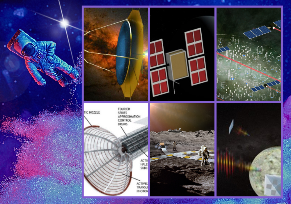
From Levitating Transport System on Moon to Plasma Rocket, NASA Updates on 6 Groundbreaking Space Technology Concepts

From Levitating Transport System on Moon to Plasma Rocket, NASA Updates on 6 Groundbreaking Space Technology Concepts

American space agency, NASA, has a program called "NASA Innovative Advanced Concepts (NIAC)", and this program has taken a significant step by advancing six groundbreaking space technology concepts to a new phase of development. These concepts, which seem like they're straight out of science fiction, have completed their initial phase and have been selected for Phase II, which includes additional funding and development.

The NIAC Phase II conceptual studies will receive up to $600,000 (~ ₹5 Crores) to continue working over the next two years to address key remaining technical and budget hurdles and pave their development path forward.

When Phase II is complete, these studies could advance to the final NIAC phase, earning additional funding and development consideration toward becoming a future aerospace mission.

Here's a brief overview of the six innovative tech concepts:

1. Fluidic Telescope (FLUTE):

The Fluidic Telescope (FLUTE) is a revolutionary concept being developed by NASA in collaboration with the Technion Israel Institute of Technology. It represents a significant leap forward in the design and construction of space observatories.

Artist’s depiction of the Fluidic Telescope (FLUTE) Edward Balaban

The FLUTE concept aims to create a large optical observatory in space using fluidic shaping of ionic liquids. It could potentially help investigate high-priority astrophysics targets, such as Earth-like exoplanets, first-generation stars, and young galaxies.

One of the most intriguing aspects of FLUTE is the concept of self-healing mirrors. These mirrors would be able to maintain their shape and repair themselves from minor damages, which is a significant advantage in the harsh environment of space.

FLUTE is designed to study high-priority astrophysics targets, including Earth-like exoplanets, first-generation stars, and early galaxies. By peering farther into space, FLUTE could help answer one of humanity's most profound questions: "Are we alone in the universe?".

2. Pulsed Plasma Rocket:


From Levitating Transport System on Moon to Plasma Rocket, NASA Updates on 6 Groundbreaking Technology Concepts


The Pulsed Plasma Rocket (PPR) is an advanced propulsion system under development that could significantly reduce travel times for human missions to Mars and beyond. The propulsion system utilizes nuclear fission, where atoms split apart to release energy. This energy is then used to create bursts of plasma for propulsion, pushing the rocket forward in space.

It may generate up to 100,000 N of thrust with a specific impulse (Isp) of 5,000 seconds. This exceptional performance combines high Isp and high thrust, which is crucial for efficient space travel over large distances.

The high efficiency of the PPR allows for manned missions to Mars to be completed within just 2 months. It also enables the transport of much heavier spacecraft equipped with shielding against Galactic Cosmic Rays, reducing crew exposure to negligible levels.

3. The Great Observatory for Long Wavelengths (GO-LoW):

The Great Observatory for Long Wavelengths (GO-LoW) is a visionary project proposed by NASA to explore the low-frequency radio sky, which has been largely inaccessible until now due to the Earth's ionosphere.

GO-LOW aims to measure the magnetic fields of terrestrial exoplanets by detecting their radio emissions at frequencies between 100 kHz and 15 MHz.

From Levitating Transport System on Moon to Plasma Rocket, NASA Updates on 6 Groundbreaking Technology Concepts
Artist concept highlighting the novel approach proposed by the 2024 NIAC Phase II awardee for possible future missions. Credits: Mary Knapp

The observatory will consist of an interferometric array of thousands of identical SmallSats located at an Earth-Sun Lagrange point, such as L5. These autonomous SmallSats satellites will measure magnetic fields emitted from exoplanets and the cosmic dark ages.

GO-LOW is part of a long-term vision to map out the technological development required to make such an observatory feasible in the next 10-20 years.

4. Radioisotope Thermoradiative Cell Power Generator:

This study investigates new in-space power sources that could operate at higher efficiencies than NASA's legacy power generators.
 
From Levitating Transport System on Moon to Plasma Rocket, NASA Updates on 6 Groundbreaking Technology Concepts
Artist’s depiction of Radioisotope Thermoradiative Cell Power Generator Stephen Polly

The Radioisotope Thermoradiative Cell (TRC) Power Generator is an innovative power source being developed for space missions, particularly those targeting the outer planets.

The TRC operates on a novel principle of thermal power conversion, somewhat akin to a solar cell working in reverse. It converts heat from a radioisotope source into infrared light, which is then emitted into the cold expanse of space. This process generates electricity.

This technology could significantly improve the capabilities of small spacecraft, enabling missions that were previously not feasible due to power constraints. It's particularly suited for operations in areas where sunlight is scarce, such as polar lunar craters or the outer reaches of our solar system. The ongoing research aims to refine the TRC technology, focusing on system size, weight, and power (SWaP), and to integrate the effects of potential power and efficiency loss mechanisms developed in Phase.

This power generation concept study is from Stephen Polly at the Rochester Institute of Technology in New York.

5. Lunar Railway System:

A concept being developed at NASA’s Jet Propulsion Laboratory for a railway system to provide payload transport on the Moon.

From Levitating Transport System on Moon to Plasma Rocket, NASA Updates on 6 Groundbreaking Technology Concepts
Artist concept of novel approach proposed by a 2024 NIAC Phase II awardee for possible future missions depicting lunar surface with planet Earth on the horizon. Credit: Ethan Schaler

The FLOAT (Flexible Levitation on a Track system) employs unpowered magnetic robots that levitate over a 3-layer flexible film track: a graphite layer enables robots to passively float over tracks using diamagnetic levitation, a flex-circuit layer generates electromagnetic thrust to controllably propel robots along tracks, and an optional thin-film solar panel layer generates power for the base when in sunlight.

This would be a lunar railway system, providing reliable, autonomous, and efficient payload transport on the Moon. This rail system could support daily operations of a sustainable lunar base as soon as the 2030s. Ethan Schaler leads FLOAT at NASA’s Jet Propulsion Laboratory in Southern California.

FLOAT robots have no moving parts and levitate over the track to minimize lunar dust abrasion / wear, unlike lunar robots with wheels, legs, or tracks.

FLOAT will operate autonomously in the dusty, inhospitable lunar environment with minimal site preparation, and its network of tracks can be rolled-up / reconfigured over time to match evolving lunar base mission requirements.

6. ScienceCraft for Outer Planet Exploration (SCOPE)

Artist’s depiction of ScienceCraft, which integrates the science instrument with the spacecraft by printing a quantum dot spectrometer directly on the solar sail to form a monolithic, lightweight structure. Mahmooda Sultana

The ScienceCraft for Outer Planet Exploration (SCOPE) is a groundbreaking mission concept developed by NASA. It aims to revolutionize the exploration of the outer planets, particularly the ice giants Neptune and Uranus, which are believed to hold secrets about the formation and evolution of our solar system.

SCOPE integrates a science instrument and spacecraft into one monolithic structure, which is a significant departure from traditional spacecraft design.

The mission utilizes a quantum dot-based spectrometer printed directly onto the solar sail material. This allows the spacecraft to not only propel through space but also to conduct scientific measurements.

These visionary studies will receive up to $600,000 each to continue working over the next two years to address technical and budget hurdles and pave their development path forward. When Phase II is complete, these studies could advance to the final NIAC phase, earning additional funding and development consideration toward becoming future aerospace missions.

Market Reports

Market Report & Surveys
IndianWeb2.com © all rights reserved